Siku Aajuitsoq aims to develop regional scale knowledge of mountain permafrost on the west coast of central Greenland. The project is the regional scale upgrade of project TEMPRA (Temperature Monitoring of Rockwalls in the Arctic). Siku Aajuitsoq takes place in the Sisimiut-Kangerlusuaq transect where mountain permafrost is surveyed using temperature monitoring and geophysics.
Background
Since increasing temperatures cause strength reduction in frozen bedrock, debris and fine sediments, warming permafrost involves a destabilization hazard for infrastructures and mountain slopes. In Greenland, slope stability is a major issue investigated by the GEUS landslide screening program. Recent events, as the 2017 landslide in the Karrak fiord, which caused a Tsunami that hit Nuugaatsiaq and Illorsuit, or the 2018 debris flow that hit Siorapalouk, are suspected to be linked to permafrost degradation. Considering that air and permafrost temperatures in the Arctic rise faster than in any other region on the globe, the scientific community suspects that these events may increase in frequency and magnitude. In addition, since Greenland is rapidly developing new large infrastructures increasing considerably the human footprint on the landscape, it is important to develop the appropriate tools for hazard assessment. In order to understand and predict these hazards, decision makers need a detailed knowledge of permafrost distribution and its characteristics.
However, since permafrost is a hidden ground property, its regional scale distribution can only be inferred by modeling the ground temperature response to climate. This is complex in mountain areas: mountain topography causes intricate patterns of ground characteristics, shading, snow and wind distribution, that in turn determine a highly variable distribution of ground temperatures and response to climate change. Obtaining significant data requires a sophisticated monitoring network that acquires ground temperatures in many different settings, exploring the spatial variability of the landscape. Due to the complexity of this task, detailed knowledge of mountain permafrost is missing Greenland, exposing the community to climate change effects on frozen grounds, without adequate tools for planning and decision-making. In this context, we started in 2020 project TEMPRA – Temperature Monitoring of Rockwalls in the Arctic – that provides mountain permafrost knowledge in the Sisimiut area.
The project Siku Aajuitsoq – the ice that never melts – is the upgrade of TEMPRA, aiming to apply its protocol at the regional scale. Siku Aajuitsoq investigates mountain permafrost along a transect from Sisimiut to the ice cap by Kangerlussuaq, developing the first large-scale detailed knowledge of its distribution and sensitivity in Greenland. Detailed knowledge on the variability of mountain permafrost in this area will allow us to understand the role of regional and local climatic and topographic patterns, creating a basis for hazard assessment of future infrastructure planning, design and maintenance . The subsurface permafrost conditions will be investigated using in situ geophysical surveys, temperature monitoring and numerical modeling of heat transfer in the ground.
FIELD CAMPAIGN
Siku Aajuitsoq started in Summer 2021 and the first fieldwork campaign took place in July-August. The fieldwork consisted of three expeditions to (i) Aqqutikitsoq, (ii) Itinneq and (iii) Kangerlussuaq. For each site we installed a ground temperature monitoring network of 20-30 loggers and measured ground resistivity in two distinct areas. These sites were selected as they provide large variability in landscape conditions, from high elevation coastal glaciers (i), subarctic mountainous terrain (ii) and dry continental cold climate (iii). By comparing the data acquired from these sites, we can observe permafrost variability depending on regional scale climate as well as local topographical influence.
Although temperature data will provide us a better picture of ground conditions after on year round of measurements, the ERT data qualitatively shows a strong influence of continentality in permafrost distribution. Ground temperatures significantly decrease in mountain terrain by approaching the inland ice. Our data suggest that low elevation mountains (100 – 200 masl) in Kangerlussuaq are significantly colder than high elevation grounds on the West coast (1000 masl). Quantitative assessment of ground temperatures based on ERT will be possible after petrophysical analysis of samples collected of the field, which will allow us to link ground temperature, water content and measured resistivity.
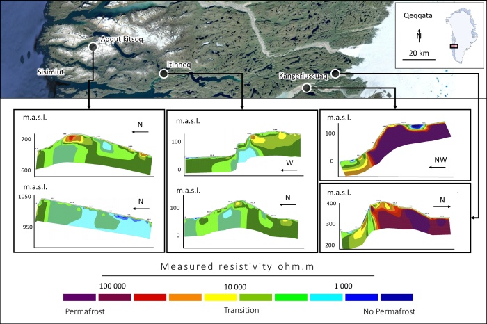
Fieldwork campaign 2021, summary of geophysical surveys. Ground resistivity is acquired for each field site across a 2D transect presenting steep topography. Increasing ground resistivity is qualitatively associated with low temperatures, suggesting permafrost presence. However, only a future detailed petrophysical analysis of ground samples collected on the field will allow to precisely determining ground temperatures. In this way, it will be possible to compare ground temperatures dependently on elevation and proximity to the ice cap.
Duration of the project:
2021-2023
Funding agency:
Nunatsinni Ilisimatusarnermik Siunnersuisoqatigiit (the Greenland Research Council)
Project partners and collaborators:
DTU Byg, Arctic DTU - Campus Sisimiut, Styx4D and KTI Råstofskolen Sisimiut