Background
In the context of climate change, the stability of arctic infrastructures is challenged. Increasing temperatures in cold regions are responsible for the modification of the ground geotechnical properties of both permanently and seasonally frozen grounds causing either a shortened life expectancy of the building or, in the most extreme case, a structural failure. These processes threaten also the stability of rock slopes, increasing the risk of rock slides and rock falls. A characterisation of this process is therefore required for valuable risk assessment in long-term urban planning and development. In cold environments, the characterisation of ground geotechnical properties and their response to climate change requires a detailed knowledge of their thermal regime. In practice, this consists in installing below the ground surface sensors recording temperature data over a longer time period. The data collected by these sensors, once coupled to meteorological data, can be used to understand the ground response to seasonal and long term temperature variations.
In Greenland there are currently several ongoing projects aimed to monitor ground thermal regimes. The GEM project (Greenland Ecosystem Monitoring), acquires shallow ground temperatures in several areas of Greenland, aiming to understand its link with ecosystem processes. ARTEK/DTU also has a ground monitoring project and several deep boreholes in sedimentary deposits across the West Coast. GEUS has recently installed temperature loggers in Sullorsuaq Strait, in order to understand the permafrost distribution in the area. Nevertheless, although these projects provide a valuable ground temperature database, the bedrock areas in the context of urban development are still unexplored to date, presenting a significant limitation in our capability of understanding the effects of climate change on Greenlandic infrastructures
The project TEMPRA aims to develop the first bedrock monitoring network in Greenland, testing a commune-scale protocol able to respond to the knowledge gap in this field. The project takes place in the Sisimiut area, where multiple temperature loggers are installed on bedrock walls and outcrops. In addition, geophysical surveys are conducted in complex terrain to obtain 2D information of subsurface temperature. The acquired data will be analyzed in relation to meteorological and snow cover conditions to better understand rock thermal regime and properties, which are linked to geotechnical characteristics relevant to infrastructure foundations and slope stability. In the specific, the project is thought to evolve around four main actions: bedrock temperature data acquisition, meteorological monitoring, landscape survey (lithology and geomorphology) and data modelling.
Field campaign
TEMPRA started in September 2020. During the first month of the project, we installed a network of 40 ground temperature loggers, focusing on the mountain terrain at the northern town boundary. The monitoring network is designed to obtain data on a large variety of ground types, elevation and aspect ranges. Most of the loggers are installed in steep or moderately steep bedrock, although some loggers are installed in sediments. The logger locations vary from sea level to 540 m.a.s.l., on both North and South facing faces. This network design will improve the significance of our observations and limit extrapolations.
In October 2020 we conducted a geophysical survey using the Electrical Resistivity Tomography (ERT) technique. The survey was conducted on two mountain ridges near town, providing subsurface conductivity data on North and South facing rock faces at 200 – 400 m.a.s.l.. The survey revealed the importance of solar radiation in determining permafrost distribution patterns in complex terrain, suggesting that south facing slopes do not host permafrost at the range of elevation investigated. These data are currently being used to set up a numerical model to link subsurface temperature to climatic forcing and ground characteristics.
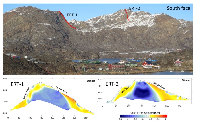
Geophysical survey summary. On top, the south facing walls investigated, seen from town. On bottom, the resistivity profiles obtained, expressed in terms of logarithmic conductivity. This parameter will be converted to ground temperature after a petrophysical analysis.
Duration of the project:
2020-2021
Funding agency:
Nunatsinni Ilisimatusarnermik Siunnersuisoqatigiit (the Greenland Research Council)